GIS Map Data
Established in State law in 1991, Utah’s State Geographic Information Database (SGID) provides one-stop download and web service access to hundreds of GIS map data layers developed, aggregated, or acquired by state government.
Aerial Imagery & Base Maps
SGID aerial photography and base map services provide critical map context for GIS and CAD users, as well as web and mobile applications. Many vintages and themes are available, created from Utah GIS data resources.
VRS GPS Network
VRS (virtual-reference-station) GPS Network is the foundation for live, up-to-sub-centimeter precision GPS field surveying, mapping, and construction. We currently maintain two networks, TURN GPS, which covers Utah and surrounding areas, and Nevada GPS covering Washoe County Nevada.
Utah Map Applications
AGRC’s development team designs, builds, and hosts cutting edge map-based web applications, custom designed to best meet specific agency/program requirements. From up-to-date Utah reference maps to custom designed web apps that best put specific agency/program information at your fingertips.
Geo APIs
Are you designing or coding an app or process that needs “Where is?” or “What’s At?" answers? Geocoding and point-in-polygon map queries are available via web APIs, from api.mapserv.utah.gov. Sign up for your complimentary account today!
News, Events, & Coordination
Utah is widely recognized as a leader in the GIS field. Coordination, partnering and information sharing — in the form of news, events, tips, and data — fuel our collective success. Sign up for our newsletter to stay in touch!
Featured News
Utah SGID Statewide Roads Data Layer Updates 10/09/2020
AGRC recently completed updates to the SGID Roads feature class. Please visit our Roads and Highway System data page where you will find information about th...
Municipal Boundaries Update for Third Quarter 2020 (Calendar Year)
As we move into the third quarter of 2020, the year is almost through. While some things have slowed down, life goes on. Annexations have been coming through...
Utah SGID Statewide Roads Data Layer Updates 09/04/2020
AGRC recently completed updates to the SGID Roads feature class. Please visit our Roads and Highway System data page where you will find information about th...
Utah SGID Statewide Roads Data Layer Updates 07/28/2020
AGRC recently completed updates to the SGID Roads feature class. Please visit our Roads and Highway System data page where you will find information about th...
GIS - Thinking Beyond the Map
If you’re reading this post, you’re already aware that geospatial technology (a.k.a. GIS) has become an essential part of our daily lives. Its capabilities e...
Enhancements to the SGID Utah Trails Dataset 06/26/2020
We are happy to announce significant updates and enhancements to the Utah Trails dataset. For one, the dataset was renamed to Utah Trails and Pathways. The n...
All Recent News Past Newsletters
Coordination, technical skills transfer, and data sharing are critical to generating effective outcomes from Utah's investment in GIS. Coordination pays off by leveraging the efforts, talents, and success within the GIS community.
AGRC encourages GIS professionals and students to periodically contribute news and updates, to both our blog pages and newsletter. Use the form at the bottom of any gis.utah.gov page to subscribe. Contact Matt Peters from AGRC at MPeters@utah.gov or 801-538-3563 to contribute.
GIS Map Data
Utah's State Geographic Information Database (a.k.a. "the SGID"), was established by policy makers to ensure that GIS map layers were developed in a coordinated fashion and shared openly, without redundant effort. Roads, boundaries, addressing, parcels, aerials, elevation, etc...you’ll find it available for download and as web services from the SGID.
The vision for the SGID was created almost two full decades before the government 'open data' and 'transparency' initiatives began hitting their stride. And, to the credit of the GIS community across the state, the SGID's GIS data resources are among the most mature and extensive in the nation.
Today, interoperable GIS server technology has diminished the importance of a completely centralized map data repository. But, it's actually more critical that the latest and best quality GIS data resources are readily discovered and accessed. And that's true for resources available to users as downloadable shapefiles as well as resources available as connections to live streaming data services. AGRC strives to ensure that the SGID stays current as a state-level channel to aide in the discovery, access, and use of GIS data resources.
Filter the master SGID Index table for data & services...
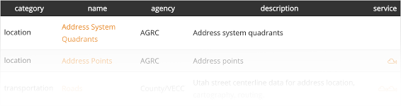
...or browse specific Data Categories
Base Maps and Imagery
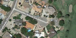
AGRC hosts aerial photography and pre-rendered base map services on its Discover cloud-based server. After obtaining an organizational login, GIS users, CAD users, and web apps can connect to these multi-scale maps using the Open Geospatial Consortium WMS and WMTS protocols. The Discover service provides images and tiles in the Web Mercator projection, an industry standard for web map display.
Layers accessible from the Discover server include themed base maps built from local & state GIS data in terrain, lite, topo, and hybrid themes. Aerial photography offerings include the latest 6" statewide imagery licensed for state, local, & tribal government from Google, as well as public domain color NAIP, Wasatch Front HRO, CIR/NRG imagery, and the historic B/W DOQ series.
Until January 31, 2017 AGRC provided base maps from its mapserv.utah.gov server in UTM NAD83 coordinates. These base map services have been retired in favor of the cloud-hosted OGC services served through Discover.
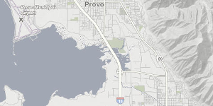
Terrain

Imagery plus Overlay base maps
Lite base map
AGRC's atlas.utah.gov website allows for a quick preview of the most popular base map services. Zoom in for richer map content, click the map for key location-specific info, and use the base map selector in the upper right corner to select your base map of choice.
Among the locally sourced map layers that AGRC incorporates into its base maps are: municipal boundaries, building-specific address points, road centerlines per UDOT specs, and State-stewarded public lands boundaries.
Discover Server Information Base Map Information Imagery Download Information
Application Development
There are many possible approaches to publishing data to web maps and web services. AGRC assists with a full range of web map solutions, from the simple to the most complex.
Our dev group specializes in custom applications, designed with agility to meet defined requirements, that maximize the communication, logical organization, and usability of information.
Some of our recent, and occasionally award-winning, work includes:
WRI (DNR-DWR)
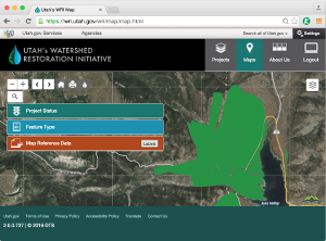
The Watershed Restoration Initiative website uses a shared web map to enable interagency project and resource coordination.
Crash Map (DPS / UDOT)
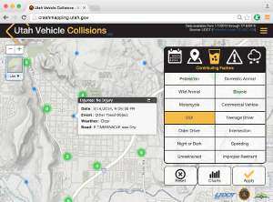
A statewide map of vehicle crashes, reported across all jurisdictions, that allows dynamic filtering for time, date, cause, severity, etc.
locate.utah.gov (GOED)
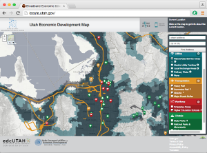
Utah's Economic Development Map depicts the landscape of what's important to businesses considering relocating to Utah.
Environmental Map (DEQ)
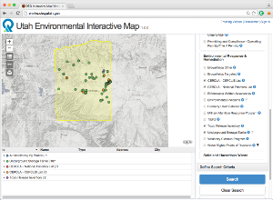
Search for site-specific information relating to DEQ programs including regulated environmental sites, facilities, and designations.
SGID Raster Search (AGRC)
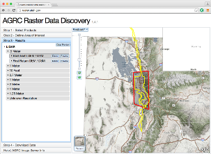
Get map-based results for all of the imagery, elevation, lidar, and scanned maps available from Utah's SGID.
SGID Parcel Viewer (AGRC)
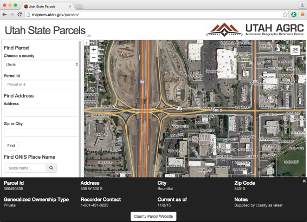
Zoom in to view parcel boundaries and basic attributes as assembled statewide by AGRC, in coordination with County Recorders.
APIs and JavaScript Widgets
APIs available through api.mapserv.utah.gov enable common tasks like address location (aka geocoding) and map search (point-in-polygon query) to be built into web applications and data-handling processes without the immediate need for GIS-specific software. These APIs are at the core of sites like Who Represents Me?, Who Taxes me? etc.
AGRC's dev group maintains a library of Utah-specific map widgets that provide common tools desired in web mapping applications. The library includes FindAddress (geocoding), TRSSearch (finds PLSS sections), and Sherlock (can be used to search for any feature in the SGID or layers in a map services. We also, on occasion publish customization for ArcGIS desktop like our geocoding api tool.
We are into git. By default, the AGRC dev team keeps its code current in AGRC's GitHub repository. If it's a web site, widget, desktop add-in, or even the content of this website itself, it should be findable, and open-sourced in the AGRC repo.