Elevation and Terrain Data
USGS 3DEP Elevation Products

The USGS 3DEP elevation products from The National Map are the primary elevation datasets available from the USGS. These elevation products are continually updated by the USGS with LiDAR collected through the 3DEP program as part of the National Enhanced Elevation Assessment. Imagery services of these elevation products are also available.
Want to determine where lidar information was used to update 5, 10, and 30 meter USGS DEM products? There are spatial metadata files for each elevation product that have polygons depicting what the source data is for the DEM in that area. They can be found on the 3DEP Product Metadata page. Links to the spatial metadata files for 5 meter, 1/3 Arc-Second (10 meter), and 1 Arc-Second (30 meter) can be found under “Standard DEMs”. The data dictionary that describes each attribute and their domains is also available from the 3DEP Spatial Metadata Glossery. PMETHOD (Production Method) is the attribute you are looking for and any polygon with a PMETHOD value of 7 has lidar as it’s source. If you need further assistance please contact the National Map Help Desk from USGS at tnm_help@usgs.gov.
The AGRC has a statewide collection of the 10 and 30 meter bare-earth DEMs. This dataset was reprojected to UTM NAD83 Zone12 meters. The vertical datum is NAVD88. The boundaries of the elevation models can be viewed in the 10 meter and 30 meter tile index shapefiles.
For information about working with elevation data in the Pro/ArcMap environment take a look at Working with Mosaic and Reference Datasets.
Related Resources
Comments, questions, compliments, or concerns can be directed to Rick Kelson from AGRC at RKelson@utah.gov.
Downloads and Web Services
Updates
- January 2018
LiDAR

Light Detection and Ranging (LiDAR) elevation data is an optical remote sensing technology that can measure the distance to, or other properties of a target by illuminating the target with light often using pulses from a laser. Currently this is the most accurate elevation dataset AGRC has but it is only available for some areas of the state. In addition to the bare-earth DEMs/DTMs and first-return DSMs, most LiDAR data also has point clouds available by request from Rick Kelson from AGRC at RKelson@utah.gov. Visit Raster.utah.gov to explore all available LiDAR collections. For more information about LiDAR visit Exploring LiDAR.
AGRC has partnered with different agencies over the years to acquire LiDAR data.
| Year | Resolution | Areas | Information |
|---|---|---|---|
| 2019 | .5 meter | Strawberry River | View |
| 2018 | .5 & 1 meter | Uintah Basin and Heber Valley | View |
| 2018 | .5 meter | Box Elder County | View |
| 2018 | .5 & 1 meter | Northern Utah | View |
| 2018 | .5 & 1 meter | Central Utah | View |
| 2018 | .5 & 1 meter | Southern Utah | View |
| 2018 | .5 meter | Sanpete Valley | View |
| 2017 | .5 meter | Millsite Reservoir | View |
| 2017 | .5 meter | Washakie and Whites Valley | View |
| 2017 | 1 meter | Washington County | View |
| 2016 | .5 meter | Kanab Utah | View |
| 2016 | .5 meter | Bear Lake, Bear River, Cache Valley & Upper Weber Valley | View |
| 2016 | .5 & 1 meter | Great Salt Lake & Utah Lake | View |
| 2016 | .5 meter | Monroe Mountain | View |
| 2016 | .5 meter | FORGE | View |
| 2015 | .5 meter | Colorado, Green & Yampa Rivers | View |
| 2015 | .5 & 1 meter | Zion National Park | View |
| 2013-2014 | .5 meter | Wasatch Front and the Wasatch Fault | View |
| 2011 | 1 meter | Great Salt Lake, Cedar Valley, Hurricane Fault | View |
| 2006 | 1 meter | Wasatch Front, Iron County, Heber Valley | View |
Related Resources
Comments, questions, compliments, or concerns can be directed to Rick Kelson from AGRC at RKelson@utah.gov.
Auto-Correlated DEM
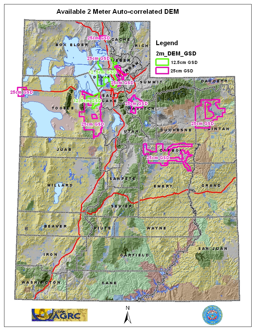
AGRC has a statewide coverage of 5 meter Auto-Correlated DEMs in addition to some 2 meter areas. The DEMs were created from the imagery collected during the 2006 NAIP and HRO aerial photography flights. The auto-correlation process is not as rigorous as other methods of elevation modeling such as photogrammetry, lidar mapping, radar mapping, etc, and therefore end-users should be aware that anomalies are expected within the elevation dataset. In comparison to the USGS DEM datasets, the 2 and 5-meter DEMs in some areas provides higher resolution and horizontal accuracy but anomalies are present within the data.
The DEM files are stored as .asc formatted files and are ~10MB per 2,000 X 2,000 meter block. This data is in a UTM NAD83 meters projection. The 2 meter DEMs have a Vertical Accuracy of RMSE 4.27' - NSSDA 95% 8.4' and a Horizontal Accuracy NSSDA, radial RMSE of 4.4', 95% confidence 7.6'. The 5 meter DEMs have a have a Vertical Accuracy of RMSE 4m - NSSDA 95% of 9.8m and a Horizontal Accuracy RMSE 3m, NSSDA 95% of 5.2m. For more information about the stated accuracy of the datasets please refer to the metadata and quality assurance reports below.
2 meter DEM
- Web Application: Download 2 meter DEMs
- Quality Assurance: Report
- Metadata: From 12.5cm Metadata, From 25cm Metadata
- Availability: Available 2 Meter DEM Map
5 meter DEM
- Web Application: Download 5 meter DEMs
- Quality Assurance: Report
- Metadata: From 1m Metadata
Related Resources
Comments, questions, compliments, or concerns can be directed to Rick Kelson from AGRC at RKelson@utah.gov.