Most Popular Datasets
State Geographic Information Database (SGID)
Established by state law in 1991, Utah’s SGID ensures that GIS map layers are developed in a coordinated fashion and shared openly. The SGID provides a one-stop access point to hundreds of data layers that were developed, aggregated, or acquired by state government. To the credit of the GIS community across the state, the SGID's data resources are among the most mature and extensive in the nation.
Today, interoperable GIS server technology has diminished the importance of a completely centralized GIS data repository, and it is critical that the latest, best quality GIS data resources are readily discovered and accessed. AGRC strives to ensure that this is true for SGID data layers that are available as downloadable shapefiles or live streaming data services.
The Open SGID
The Open SGID is a cloud-hosted PostGIS database containing the datasets from the SGID which are also available from the AGRC Open Data. It is a publicly-available, direct database connection that can be utilized on a multitude of GIS platforms to access Utah spatial data. A GitHub repository is used as the primary source of information for the Open SGID, and to catalog and address issues with explanations and or troubleshooting techniques. Please read, understand, and abide by the terms of use prior to connecting.
SGID Index
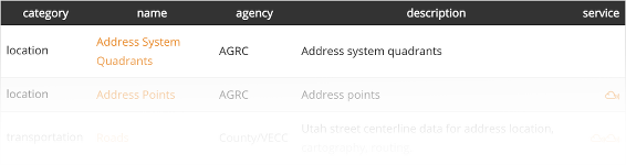
The SGID Index is a sortable and filterable table containing data items contained in our SGID. It is a great resource to quickly find GIS data and resources important to you. In the SGID Index, you will find the ISO category, the name of the resource, the agency who is the data steward, a short description and a link to a service endpoint if one is available.
Raster Discovery and Download
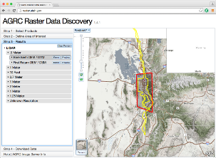
The Raster Discovery App allows users to get map-based results for all of the imagery, elevation, lidar, and scanned maps available from Utah's SGID. Select the types of products you are interested in. Next, define your area of interest. The Raster Discovery App will search the product indices and produce a resulting list of items that intersected your area of interest. Finally, download the data!
Data Categories
Contributing to the SGID
If you are stewarding Utah GIS data layers, the best return on your hard work and on your agency's investment are found by ensuring your data resources are discoverable.
Getting GIS data listed within the SGID index increases the odds it won't be created duplicatively by others and that the data can be found by users in need. And, where appropriate and desired, AGRC can host your data as live services or for download.
If your agency hosts AGOL web services that are relevant to the Utah GIS community, please read our guide on how to share them and make them discoverable via AGRC's SGID Open Data site.
If you have additional questions or other data files or web services that should be included in the Utah SGID, please contact Zach Beck from AGRC at ZBeck@utah.gov or 801-538-3072, or Michael Foulger from AGRC at MichaelFoulger@utah.gov or 801-652-2258 or anyone else on the AGRC team.
More information about the core datasets AGRC regularly updates and what you can contribute can be found from the GIS Data Sharing page.