Statewide Contours
- Category: Elevation-and-terrain
- Data Type: GIS Data Layer
- Steward(s): AGRC
- Web Application: View
- Abstract: This datasets contain a statewide coverage of 500 foot contours derived from the 10 meter National Elevation Datasets (NED) Digital Elevation Model (DEM).
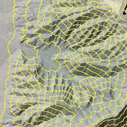
500 Foot Contours

ELEVATION.Contours500Ft is a statewide dataset of contour lines at a 500 foot interval for cartography and approximate elevation identification. Elevation information is stored in the 500 Foot contour lines in an attribute ELEV associated with each contour isoline.
The native spatial reference for this dataset is UTM Zone 12N, NAD83. There are no constraints or warranties with regard to the use of this dataset. Users are encouraged to attribute content to: State of Utah, SGID. This contour dataset was created by AGRC.
Comments, questions, compliments, or concerns can be directed to Zach Beck from AGRC at ZBeck@utah.gov or 801-538-3072.
Downloads and Web Services
Updates
- This dataset has not been updated recently.
Generalized Contour Polygons 200 Foot

SGID10.ELEVATION.ContoursGeneralized200Ft are intended for general cartographic purposes and representing approximate elevation and terrain. Contours were created by applying a focal filter to a 30 meter DEM, reclassifying the DEM into 200 foot intervals and converting to polygons. Would you like to create your own contour polygons or are you simply curious how it was done? Read the in-depth discussion of how the contours were created and derived.
Comments, questions, compliments, or concerns can be directed to Zach Beck from AGRC at ZBeck@utah.gov or 801-538-3072.
Downloads and Web Services
Updates
- As needed