2 Meter LiDAR Elevation Data (2006)
2 Meter LiDAR Elevation Data from 2006
- Category: Elevation-and-terrain
- Data Type: asc format LiDAR
- Steward(s): AGRC
- Web Application: 2 meter Bare Earth DEMs
- Web Application: 1.25 meter Bare Earth DEMs and Raw XYZi LiDAR
- Web Application: 1 meter Bare Earth DEMs, First Return DEMs, Last Return DEMs, and Raw XYZi LiDAR
- Abstract: AGRC has 1, 1.25, and 2 meter LiDAR in .asc format for various areas of the state collected during 2006.
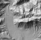
2 Meter LiDAR
Use this shapefile to determine what files to download in the Wasatch Front area. The Heber Valley and Iron County areas download as complete areas in a .zip file. These LiDAR files are in a .asc format and are around 10 mb per 2,000 X 2,000 meter block. This data has a UTM NAD83 NAVD88 Meters zone 12 Geoid 03 projection.
- How to use ASCII files in ArcMap
- 2 meter LiDAR Report, Information, and Specifications
- 2 meter LiDAR QA Report
- 2 meter LiDAR Metadata
Comments, questions, compliments, or concerns can be directed to Rick Kelson from AGRC at RKelson@utah.gov.
Downloads and Web Services
Updates
- 2006
1.25 Meter LiDAR
- 1.25 meter Bare Earth and Raw XYZi LiDAR Interactive Map
- 1.25 meter LiDAR Report
- 1.25 meter LiDAR Metadata
Comments, questions, compliments, or concerns can be directed to Rick Kelson from AGRC at RKelson@utah.gov.
Downloads and Web Services
Updates
- 2006
1 Meter LiDAR
- 1 meter Bare Earth, First and Last Return, and Raw XYZi LiDAR Interactive Map
- 1 meter LiDAR Report
- 1 meter LiDAR Metadata
Comments, questions, compliments, or concerns can be directed to Rick Kelson from AGRC at RKelson@utah.gov.
Downloads and Web Services
Updates
- 2006